Subtotal:
$0


Drone Detection Systems & Counter-UAS (C-UAS) Solutions in Africa
Drone Detection Systems & C-UAS Solutions Across Africa: A Specialist Implementation Guide
The Best Drone Detection Systems Africa
Introduction
Africa’s airspace is changing. The proliferation of low-cost unmanned aerial systems has created new security challenges for military installations, border posts, airports, prisons, critical infrastructure, and major events across the continent. From the Sahel to the Cape, from the Gulf of Guinea to the Horn of Africa, drones are being used for surveillance, smuggling, and increasingly as tactical threats against security forces and protected assets.
This guide examines the operational realities of drone detection and Counter-UAS (C-UAS) deployment in African environments. It is written for the decision-makers who must navigate these challenges: military planners, defence procurement teams, police commanders, critical-infrastructure operators, and security directors evaluating C-UAS options.
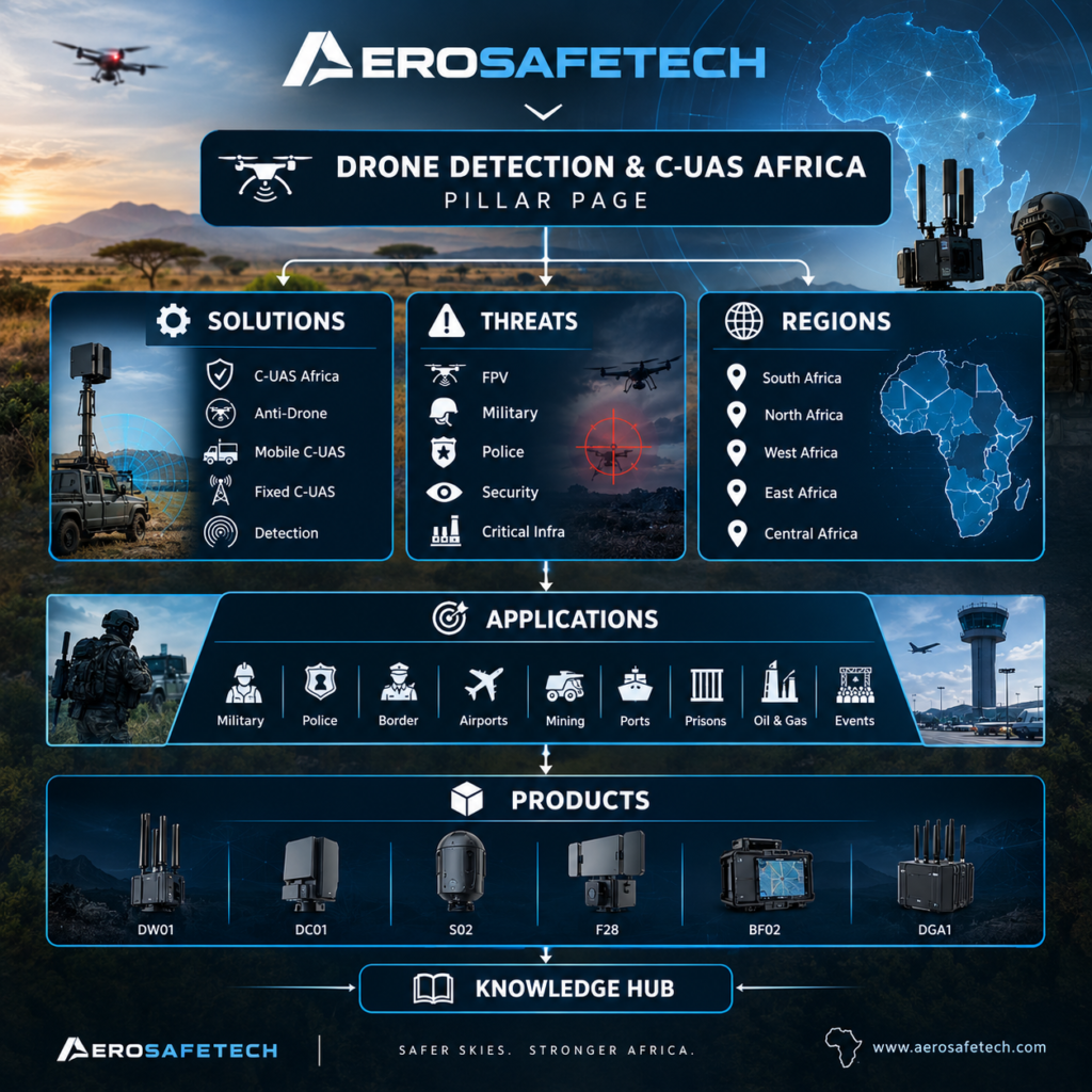
AeroSafeTech specialises in drone detection and integrated C-UAS solutions for African operating conditions. Our approach follows a clear methodology: Detection → Identification → Localization → FPV Detection → Authorised Countermeasures. This is not a single-device proposition. Effective drone security requires layered capability matched to specific threats, sites, and missions.
Understanding the Drone Threat in African Contexts
Why drones present a distinct security challenge
Small unmanned aircraft are difficult to detect with conventional security systems. They are low-radar-cross-section targets that can operate at night, in urban clutter, and from concealed launch points. Their operators may be kilometres away. A drone weighing under 1 kilogram can carry a payload sufficient to cause significant disruption or harm.
In African operational environments, the challenge is compounded by geography and infrastructure. Vast border regions, remote industrial sites, and distributed critical infrastructure create broad attack surfaces. Traditional perimeter security—fences, guards, CCTV—was not designed to address airborne threats.
Threat categories relevant to African operators
- Military and defence: Hostile reconnaissance, artillery spotting, loitering munitions, and FPV attack drones in conflict zones.
- Border security: Cross-border smuggling of contraband, weapons, and persons, with drones used for surveillance or payload delivery.
- Critical infrastructure: Unauthorised surveillance of power stations, pipelines, ports, and telecommunications facilities.
- Correctional facilities: Contraband delivery into prison grounds.
- Airports: Disruption of flight operations through unauthorised airspace incursion.
- Events and VIP protection: Privacy breaches, surveillance, and potential payload threats at public gatherings.
The Counter-UAS market in Africa is expanding across military, homeland security, and commercial sectors. This growth reflects recognition that drone threats require dedicated detection and response capabilities.
Detection vs. C-UAS: Understanding the Distinction
A common procurement error is treating “drone detection” and “counter-UAS” as synonymous. They are not.
Drone detection is the capability to identify the presence of an unmanned aircraft. It answers the question: Is there a drone?
C-UAS (Counter-UAS) encompasses the full spectrum of activities: detection, identification, localization of both the drone and its pilot, tracking, and—where legally authorised—countermeasures. It answers the questions: What is it? Where is it? Who is controlling it? What should we do about it?
Detection is the foundation. Without reliable detection, no subsequent response is possible. But detection alone is not a C-UAS capability. Organisations that purchase a detection system expecting it to solve their drone problem often find themselves able to observe a threat without the capacity to respond appropriately.
A layered architecture typically includes detection (RF scanning, radar, acoustic), identification (protocol analysis, Remote ID, DroneID), localization (direction finding, protocol-based positioning), and—where authorised and appropriate—countermeasure options.
How Drone Detection Systems Work
RF Detection and Spectrum Analysis
Most commercial and tactical drones communicate with their operators via radio frequency links. These links may operate in the 2.4 GHz and 5.8 GHz bands (common for consumer drones), 433 MHz, 900 MHz, and various other frequencies. RF detection systems passively monitor the electromagnetic spectrum for signals characteristic of drone communication.
This approach is passive—the detection system emits nothing, making it covert and non-interfering. It can identify not only the presence of a drone but often the specific protocol or frequency band, which assists in classification.
Key limitation: RF detection depends on the drone emitting a detectable signal. Drones operating autonomously, on pre-programmed routes, or with modified communications may not be detected by RF alone.
Protocol Analysis, Remote ID, and DroneID
Modern drones increasingly broadcast identification information. Remote ID (RID) is a standard that allows compliant drones to broadcast their identity, position, and operator location. DroneID is a proprietary identification capability used by DJI and some other manufacturers.
Systems that can parse these protocols provide valuable identification data: drone serial number, model, position, altitude, velocity, and in some cases operator location. This moves the capability from mere detection to identification.
Limitation: Non-compliant or modified drones may not broadcast RID or DroneID. Hostile actors are unlikely to cooperate with identification protocols.
FPV Detection and Analog Video
First-Person View (FPV) drones often use analog video transmission, which presents different detection challenges than digital control links. FPV signals may be weaker, operate in different frequency bands, and require dedicated detection capabilities.
FPV drones are increasingly used in tactical military contexts. Their detection requires systems specifically configured to identify analog video signatures in relevant bands.
Direction Finding and Localization
Detection tells you a drone is present. Localization tells you where—both the aircraft and, critically, the operator. Direction-finding antennas and protocol-based positioning techniques can geolocate the drone and its pilot, enabling security forces to respond to the source of the threat rather than merely observing the aircraft.
Layered Detection Architecture: Why One Sensor Is Not Enough
No single detection technology provides complete coverage. This is a foundational principle in C-UAS design.
RF detection is effective for the majority of commercial drones but blind to autonomous or RF-silent platforms.
Radar can detect physical objects regardless of emissions but struggles with small targets in clutter and may require significant infrastructure.
Electro-optical/infrared cameras provide visual confirmation but have limited detection range and are affected by weather and lighting.
Acoustic sensors can detect drones in specific environments but have short range and are susceptible to noise interference.
The European Commission’s guidance on UAS detection for critical infrastructure explicitly encourages combining multiple sensor types to mitigate individual limitations and reduce false positives. This is particularly relevant in African environments where terrain, electromagnetic interference, and infrastructure constraints vary widely.
A typical layered approach might combine RF detection for broad awareness, protocol analysis for identification, direction finding for localization, and FPV-specific detection for analog video threats.
AeroSafeTech’s Methodology: Detection → Identification → Localization → FPV Detection → Countermeasures
AeroSafeTech approaches C-UAS as an integrated capability, not a product transaction.
Detection
The first layer establishes awareness. RF detection systems scan for drone communication signals across relevant frequency bands. Depending on the system, this may cover 0–8000 MHz (AST-DW01) or 70 MHz–6.2 GHz (AST-DGA1). Detection range varies by system and environmental conditions—the AST-DGA1 has a stated overall detection range of ≥10 km LOS under specified test conditions.
Identification
Once a signal is detected, identification determines what type of drone is present. Protocol analysis, Remote ID parsing, DroneID analysis, and signal fingerprinting provide specific information: manufacturer, model, and in some cases the drone’s unique identifier.
Localization
Localization answers where. Direction-finding antennas and protocol-based positioning techniques locate both the drone and its operator. This is operationally critical for interdiction. The AST-DC01 supports protocol-based positioning, and the AST-DGA1 provides 360° horizontal detection with direction finding and real-time trajectory display.
FPV Detection
FPV drones using analog video require dedicated detection. The AST-DGA1 includes dedicated analog FPV video detection with a stated detection range of ≥1.5 km LOS under specified test conditions. The AST-DW01 includes analog video capture capability and OFDM HD image transmission signal identification.
Authorised Countermeasures
Where legally authorised and operationally appropriate, countermeasure options may be integrated. AeroSafeTech provides countermeasure-capable systems, but deployment must be governed by regulatory authorisation, rules of engagement, and site-specific assessment. Detection always precedes response.
Portable, Mobile, and Fixed C-UAS: Matching Deployment to Mission
Portable Detection Systems
Portable systems prioritise mobility and rapid deployment. The AST-DW01 weighs approximately 580 g (main unit without antenna), operates on a removable lithium battery for approximately 7 hours under stated conditions, and covers 0–8000 MHz. It is suited to foot patrols, temporary positions, and situations where a lightweight, man-portable detection capability is required.
Vehicle-Mounted and Mobile Systems
Mobile C-UAS systems are deployed on vehicles or configured for rapid relocation. They suit military patrols, border security operations, convoy protection, and temporary security zones. The AST-DC01 is a portable detection, identification, and localization system with a 13.3-inch display and dual-battery configuration for approximately 6–7 hours endurance.
Fixed-Site Systems
Permanent installations require comprehensive coverage, integration with existing security infrastructure, and continuous operation. The AST-DGA1 supports fixed deployment with cloud/software platform integration, tracking, whitelist/blacklist functions, GIS, logging, and playback. It is IP66-rated and operates from approximately -40°C to +60°C.
African Deployment Considerations
Terrain and Environment
African operating environments vary dramatically. High-temperature conditions, dust, humidity, and weather exposure affect equipment selection and performance. The AST-DW01 operates from approximately -20°C to +60°C with IP54 rating. The AST-DGA1 operates from approximately -40°C to +60°C with IP66 rating.
Electromagnetic Environment
Urban and industrial areas present complex RF environments with multiple signal sources. Detection systems must be configured and calibrated for the specific electromagnetic environment of each site. False positives from Wi-Fi, Bluetooth, and other emitters must be managed through system tuning and operator training.
Infrastructure and Power
Remote sites may have limited grid power and connectivity. System selection must account for power availability, battery endurance, and data transmission options. Portable and battery-operated systems reduce infrastructure dependency.
Fixed vs. Mobile Deployment
The choice between fixed and mobile deployment depends on the mission. Border security may require mobile systems for patrol coverage across wide areas. Critical infrastructure sites may benefit from fixed detection with integrated command software. Many organisations require both.
Regulatory Considerations
C-UAS deployment—particularly countermeasure capabilities—is subject to national laws and regulations. These vary by country. Organisations must verify applicable legal requirements and obtain appropriate authorisation before deploying any countermeasure capability. AeroSafeTech advises all clients to consult relevant national authorities and legal counsel.
Application Areas Across Africa
Military and Defence
Military forces require force protection, base perimeter security, and mobile detection for patrols and temporary positions. FPV detection is increasingly relevant given the use of FPV drones in contemporary conflict. A layered approach combining portable detection, vehicle-mounted systems, and fixed-site capability provides flexibility.
Police and Law Enforcement
Police operations include event security, VIP protection, prison perimeter monitoring, and public order situations. Detection and localization capabilities support interdiction of unauthorised drone activity. Evidence logging and operator workflow are important considerations.
Border Security
Border agencies face wide-area surveillance challenges. Mobile and portable detection systems can complement existing border security infrastructure. Long-range detection and localization capabilities support interception operations.
Critical Infrastructure
Power stations, pipelines, ports, airports, and telecommunications facilities require protection from unauthorised surveillance and potential attack. Fixed detection with command software integration supports continuous monitoring and response coordination.
Airports
Airport environments present unique challenges: high RF noise, strict regulatory requirements, and the need to avoid interference with aviation systems. Detection system selection must account for electromagnetic compatibility and coordination with aviation authorities.
Prisons
Correctional facilities face contraband delivery via drone. Perimeter detection, early warning, and localization support interdiction. Portable systems can supplement fixed installations.
Mining and Oil & Gas
Remote industrial sites require protection across large areas. Mobile patrols, fixed detection, and integration with existing surveillance systems support security operations. Environmental conditions—heat, dust, and vibration—influence equipment selection.
Evaluating C-UAS Solutions: A Procurement Framework
Define the Threat
Before evaluating systems, define the threat profile: What drone types are relevant? What is the likely mission—surveillance, payload delivery, or attack? What is the expected operating environment?
Define the Mission
What must the system enable? Detection only? Detection and identification? Localization for interdiction? Authorised countermeasures? The required capability determines the system architecture.
Conduct a Site Assessment
Every site has unique characteristics: terrain, electromagnetic environment, existing infrastructure, and coverage requirements. A site assessment identifies blind spots, interference sources, and integration opportunities.
Evaluate Detection Performance Realistically
Stated detection ranges are test-condition figures, not guarantees. Performance varies with drone type, signal strength, terrain, weather, and electromagnetic interference. A pilot deployment in the actual operating environment provides the most reliable performance data.
Consider Integration and Operator Workflow
Detection systems must integrate with existing security operations. Command software, alarm handling, operator interfaces, and response protocols all affect operational effectiveness.
Address Regulatory and Governance Requirements
Countermeasure deployment requires legal authorisation and clear rules of engagement. Detection-only systems may be subject to fewer restrictions but still require governance frameworks.
AeroSafeTech Solutions Overview
AeroSafeTech provides a range of detection and C-UAS systems configured for African operating environments.
AST-DW01: Portable detection system, 0–8000 MHz receiving range, approximately 580 g main unit, ≥1 km detection under stated conditions, analog video capture, OFDM HD signal identification, FM analog image transmission identification, vibration/sound alarms, removable lithium battery, approximately 7 hours per battery, IP54.
AST-DC01: Portable detection, identification, and localization system. 100 MHz–6 GHz passive receiving. CRPC analysis, Remote ID analysis, DroneID analysis. Stated 0–5 km detection/analysis under specified test conditions. Protocol-based positioning. 13.3-inch display. Dual battery, approximately 6–7 hours endurance. IP66 closed.
AST-DGA1: Long-range detection and C-UAS platform. 70 MHz–6.2 GHz. Full-band scanning and spectrum analysis. Dedicated analog FPV video detection with stated ≥1.5 km LOS under specified test conditions. Stated overall detection range ≥10 km LOS under specified conditions. DID and RID capability. Supports DJI and other mainstream UAVs with applicable identification. 360° horizontal detection. Direction finding. Real-time trajectory display. Optional countermeasure configurations. Cloud/software platform. Automated/manual modes. Tracking, whitelist/blacklist, GIS, logs, playback. Optional AI learning. IP66. Approximately -40°C to +60°C.
AST-S02 GAN: Countermeasure-capable system. Frequencies below 2.4 GHz and between 5.2–5.8 GHz. 30W + 30W. Approximately 1.2 kg. Two omnidirectional antennas. 24V/3.2Ah battery. Operating temperature approximately -30°C to +70°C.
AST-F28: 8-band countermeasure configuration. 30W + 30W as supplied. Approximately 23.8 kg. Customisable frequency bands subject to configuration. 6 low-frequency + 2 high-frequency bands.
AST-BF02: Integrated detection/countermeasure platform. Detection 300 MHz–6 GHz. Approximately 70 kg. Supplied countermeasure channels include approximately 840–930 MHz, 1535–1635 MHz, 2380–2520 MHz, 5130–5370 MHz, 5725–5885 MHz, and 1080–1200 MHz ranges.
All countermeasure-capable systems must be deployed with appropriate authorisation, governance, and rules of engagement.
Pilot Deployment: Validating Performance Before Commitment
A pilot deployment is the most reliable way to evaluate C-UAS performance in actual operating conditions. It allows organisations to:
- Test detection performance against realistic drone targets
- Assess false positive rates in the specific electromagnetic environment
- Evaluate operator workflow and integration with existing systems
- Identify coverage gaps and optimisation opportunities
- Validate performance against mission requirements
A structured pilot typically involves defined test scenarios, performance measurement against agreed criteria, and a report documenting findings. This evidence-based approach supports procurement decisions and reduces deployment risk.
Frequently Asked Questions: Drone Detection Systems & C-UAS Solutions Across Africa
What is the difference between drone detection and counter-UAS?
Drone detection identifies the presence of an unmanned aircraft. Counter-UAS (C-UAS) encompasses detection, identification, localization, tracking, and—where authorised—countermeasures. Detection is the foundation of C-UAS but does not by itself provide a response capability.
Can a single detection system protect a large site?
No single sensor provides complete coverage. Large sites typically require layered detection combining multiple technologies and strategically positioned sensors. Site assessment determines optimal placement and configuration.
How far can drone detection systems detect?
Detection range varies by system, drone type, signal strength, terrain, and environmental conditions. Stated ranges are test-condition figures, not guaranteed real-world performance. A pilot deployment in the actual operating environment provides the most reliable data.
Are countermeasures legal in all African countries?
No. Regulations vary by country and countermeasure deployment requires appropriate authorisation. Organisations must verify applicable national laws and obtain necessary approvals before deploying any countermeasure capability.
What is FPV detection and why does it matter?
FPV (First-Person View) drones often use analog video transmission, which requires dedicated detection capabilities. FPV drones are increasingly relevant in tactical military contexts and present different detection challenges than conventional drones.
Can detection systems identify the drone operator?
Yes. Direction-finding and protocol-based positioning techniques can localize the drone operator, enabling interdiction. This is operationally critical for security forces.
How long does a pilot deployment take?
Duration depends on mission complexity and evaluation criteria. A focused pilot testing specific scenarios might take days; a comprehensive evaluation across multiple conditions may take weeks or months.
What infrastructure is required for a fixed C-UAS installation?
Requirements vary by system but typically include power, network connectivity, mounting structures, and integration with security operations. Portable and mobile systems reduce infrastructure dependency.
Can drone detection systems work in remote areas with limited power?
Yes. Portable and battery-operated systems are designed for remote deployment. Battery endurance under stated conditions ranges from approximately 6–7 hours for some systems. Spare batteries extend operational time.
Drone Detection Systems & C-UAS Solutions Across Africa : A Layered Approach to Drone Security in Africa
Drone threats to African military, security, and critical-infrastructure organisations are real and evolving. No single device or technology provides complete protection. Effective C-UAS requires a layered approach matched to specific threats, sites, and missions.
AeroSafeTech specialises in drone detection and integrated C-UAS solutions for African operating environments. Our methodology—Detection → Identification → Localization → FPV Detection → Countermeasures—reflects the operational reality that awareness precedes response, and that response must be authorised, governed, and proportionate.
Whether you are evaluating detection options, planning a pilot deployment, or developing a C-UAS programme, we can provide technical guidance and system options matched to your requirements.
Request a C-UAS Assessment or Discuss Your Drone Detection Requirements with our team. We will work with you to define the threat, assess your operating environment, and recommend a layered approach.
Talk to AeroSafeTech about your drone security requirements.